Stop losing hours to scattered property checks.
Run value, risk, zoning, and market evidence in one workflow so your team can decide faster with confidence.
Time saved
Faster first-pass diligence
Risk surfaced early
Constraints visible before deeper spend
Decision confidence
Evidence-backed recommendation ready to share
102M+
searchable lots
1.2M+
active listings
47
prefectures
106.8M+
data points
Trusted by professionals across Japan
Teams use JPR to move from raw research to a clear property recommendation without rebuilding the story in spreadsheets and chat threads.
Preview Latest Added Properties Before You Sign Up
See what just hit the market and where price signals are moving. Full address and broker details unlock after free signup.
Latest Added
Sorted by newly added
Trending Picks
Recent price movement
Why teams trust the output
Evidence your team can defend.
Every recommendation is traceable to sources, refresh timing, and method so decisions are easier to trust internally and with clients.
Official source provenance
Each layer is tied to official publishers such as MLIT and local government open data portals.
Public-release refresh cycle
Datasets are refreshed in line with public release schedules to minimize stale information.
Verification workflow
We standardize and validate records before publication so map layers stay consistent across regions.
Methodology transparency
We clearly separate official records from platform-derived signals so confidence is easier to assess.
Sample output
From property data to a decision summary your team can act on.
This sample shows how value range, constraints, and market signals become a practical proceed, hold, or reject call.
Fast value-range screening
Start with a directional value range anchored to official prices, comparable signals, and live listings.
Constraint checks in one place
Review hazard, zoning, access, and school context together so major blockers appear early.
Recommendation with source trail
Deliver a decision summary that teammates and clients can review without guessing where the conclusion came from.
Sample summary
Decision summary
Expected land value
¥45.8M
One module in the summary: a directional land-value range for screening.
Low
¥38.5M
Expected
¥45.8M
High
¥53.2M
Confidence
ModerateConfidence improves when nearby official points and comparable transactions line up with current listing signals.
Attached evidence
Use this as a screening summary, not a certified appraisal.
Why the recommendation holds up
The output is only useful if the underlying evidence is traceable. These are the core inputs behind each property decision.
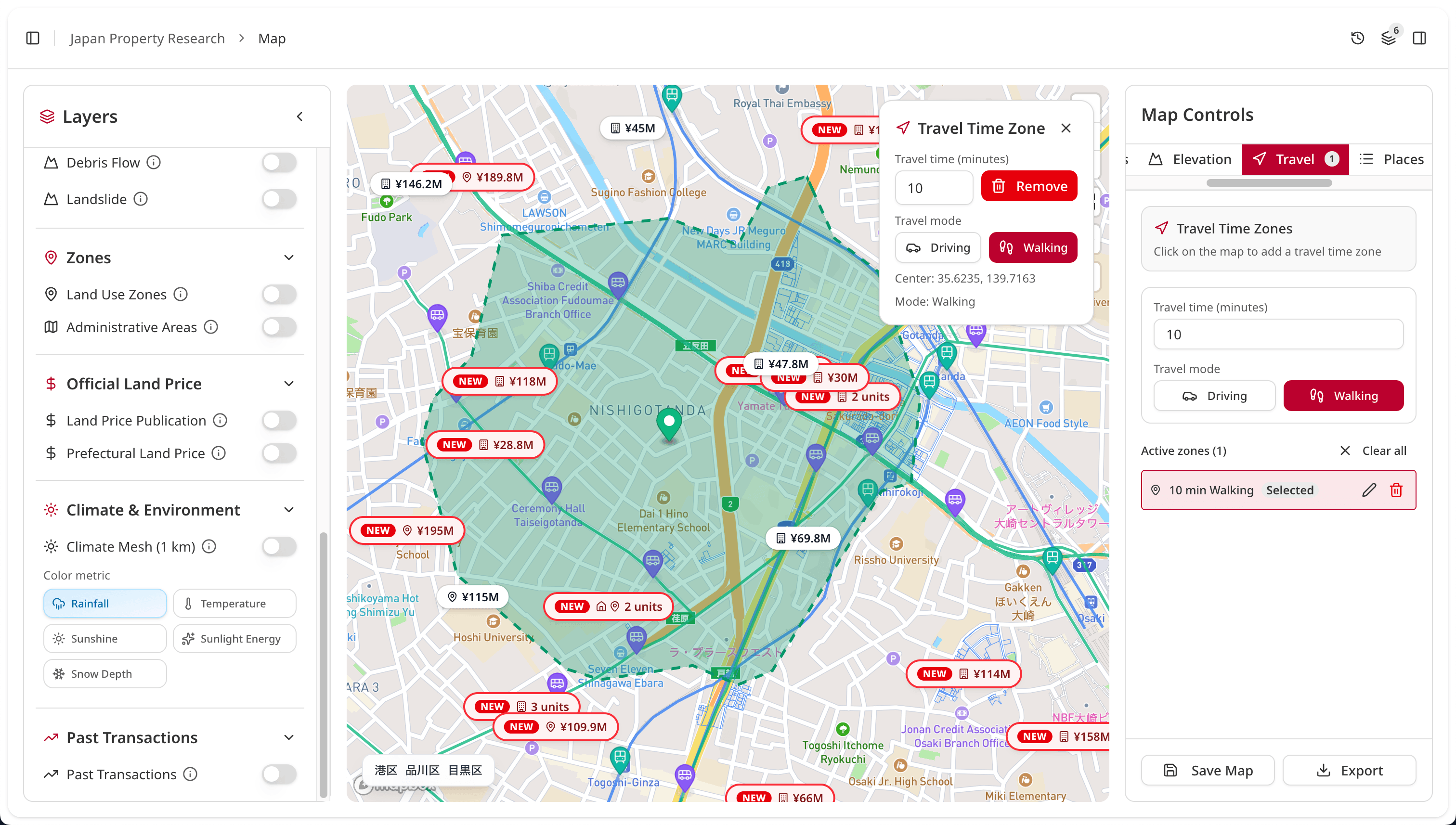
Check value, constraints, safety, and market reality before you spend more time on the site.
Official and authoritative sources, refreshed on public release cycles.
Boundaries
Which lot are we actually deciding on?
Lot boundaries and official lot numbers (地番) for all of Japan—over 102 million searchable lots.
Everything else depends on knowing which piece of land is which. Boundaries connect zoning, hazards, and school districts to the right property.
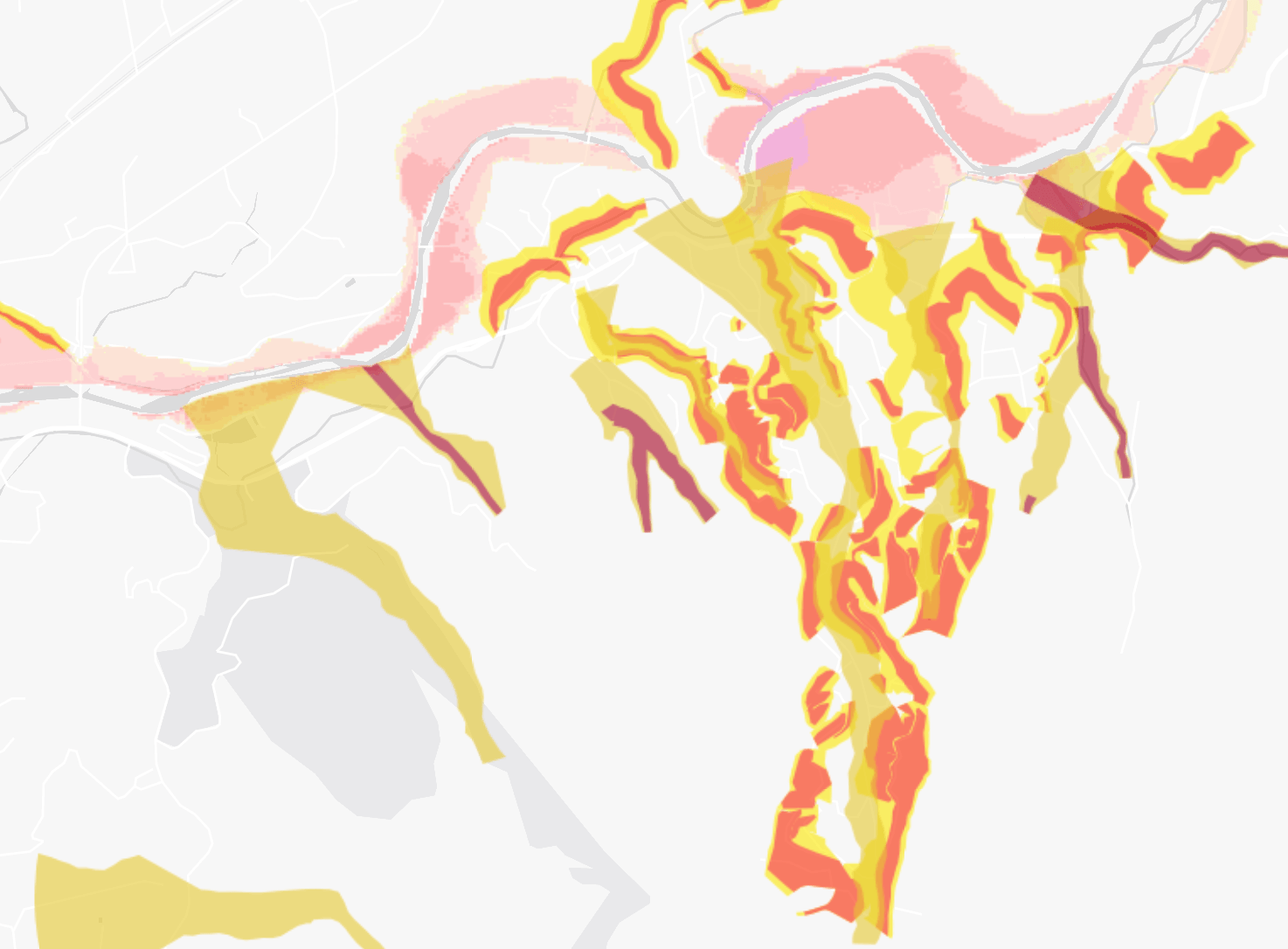
Risk
Will risk change the call?
Official maps showing flood, landslide, and liquefaction risk for an area.
Risk affects insurance costs, resale value, and peace of mind. High-risk areas can limit financing options and reduce buyer interest.
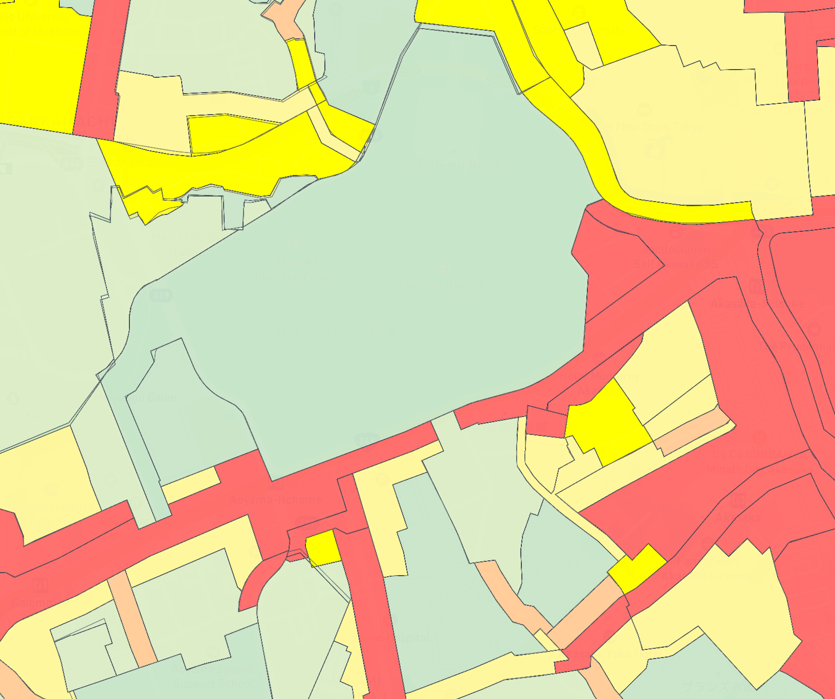
Regulation
What can this site actually become?
Government designations that define what you can build—residential, commercial, mixed use, height limits.
Zoning rules decide what can be built—a house, a shop, or something taller. This directly affects property value and how the land can be used.
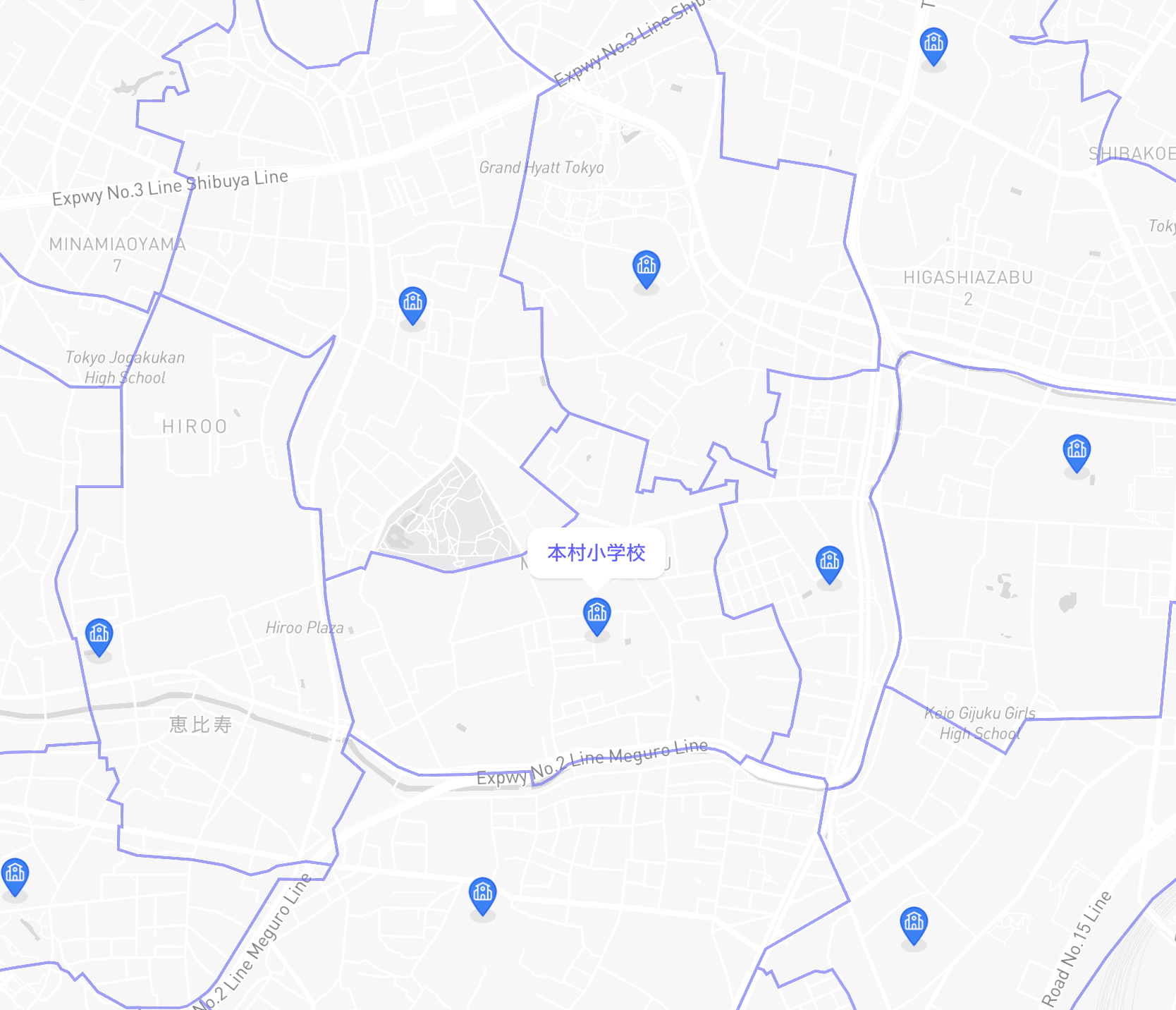
Education
Will location context strengthen demand?
Which public elementary and junior high school a property belongs to.
Families care a lot about which school their kids will attend. Good school districts typically drive higher demand and stronger resale value.
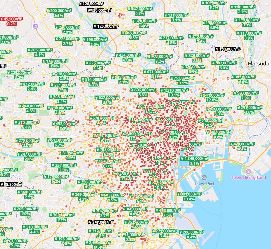
Value
Is the price grounded in reality?
Official published land prices used as a reference for market value and taxes.
Provides market context for evaluating prices, making offers, and understanding tax implications. A reality check against local market values.
Boundaries
Which lot are we actually deciding on?
Lot boundaries and official lot numbers (地番) for all of Japan—over 102 million searchable lots.
Everything else depends on knowing which piece of land is which. Boundaries connect zoning, hazards, and school districts to the right property.
Risk
Will risk change the call?
Official maps showing flood, landslide, and liquefaction risk for an area.
Risk affects insurance costs, resale value, and peace of mind. High-risk areas can limit financing options and reduce buyer interest.
Regulation
What can this site actually become?
Government designations that define what you can build—residential, commercial, mixed use, height limits.
Zoning rules decide what can be built—a house, a shop, or something taller. This directly affects property value and how the land can be used.
Education
Will location context strengthen demand?
Which public elementary and junior high school a property belongs to.
Families care a lot about which school their kids will attend. Good school districts typically drive higher demand and stronger resale value.
Value
Is the price grounded in reality?
Official published land prices used as a reference for market value and taxes.
Provides market context for evaluating prices, making offers, and understanding tax implications. A reality check against local market values.
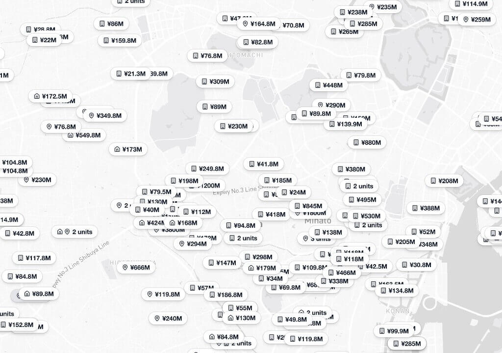
Market
What is the market saying right now?
1.1M+ active property listings across Japan with prices, locations, and details directly on the map.
See what's actually for sale right now. Real listings with real prices help understand current market conditions and what properties are worth.
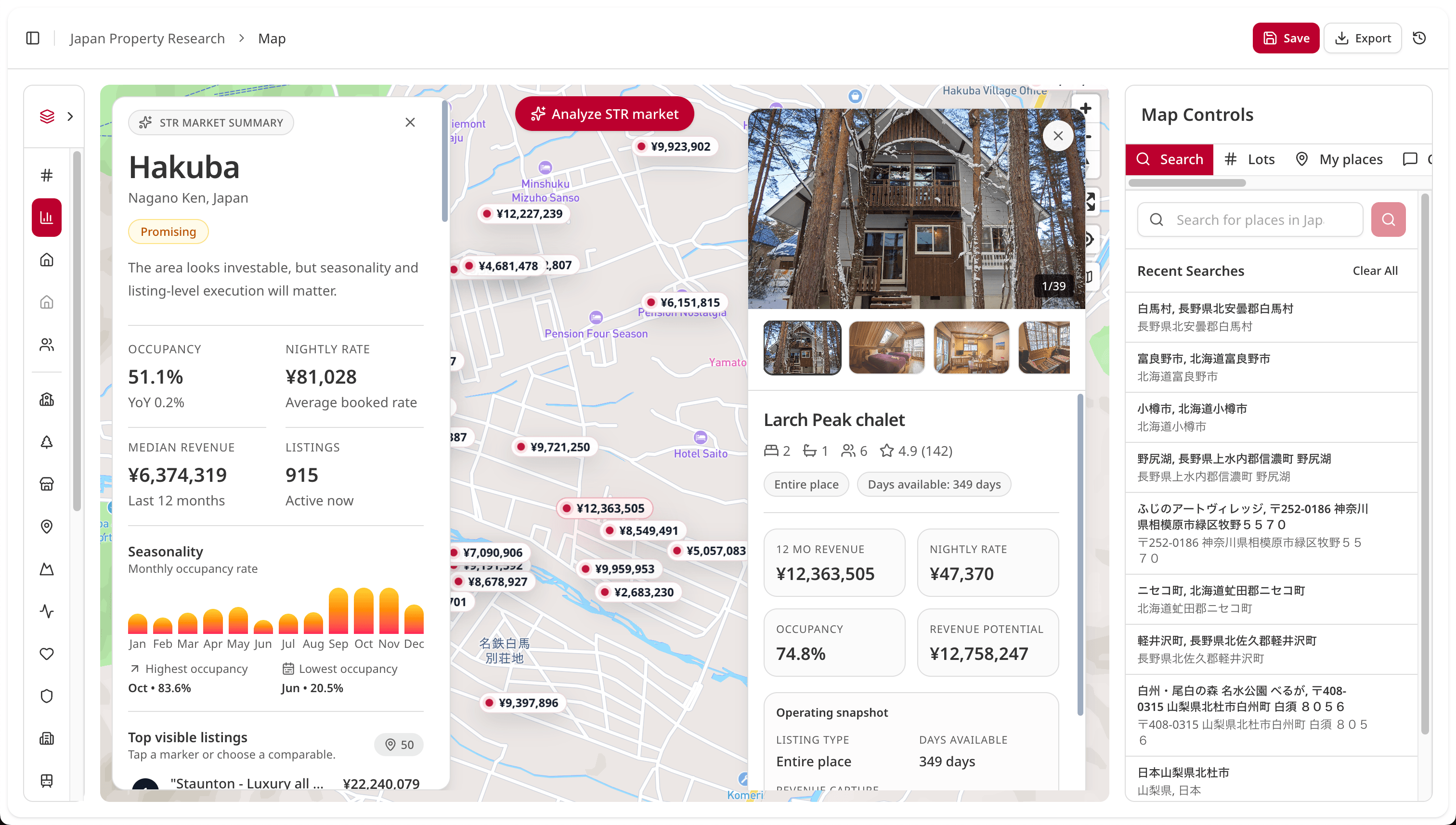
Check short-term rental viability before committing more budget.
See demand, pricing, seasonality, and nearby comparables in one view so you can quickly decide if STR upside is real or risky.
Available directly in your core map workflow.
Screen demand faster
See occupancy, nightly rate, and recent revenue benchmarks before you invest more research time.
Benchmark nearby winners
Compare nearby listings by capacity, reviews, and quality so your assumptions stay grounded.
Avoid fragile markets
Catch thin inventory or extreme seasonality early and avoid low-confidence bets.
Property Registration
Need the official registration record for a property in Japan?
Request a copy on our platform. We deliver documents by email and keep them in your account.
01
What You Get
An official copy of the property registration record for the selected lot or building.
02
What It Includes
Registered details such as property identifiers, ownership entries, and recorded rights.
03
Delivery and Access
Track request status, receive documents by email, and download them later from your account.
Onigiri Newsletter
Big market, small bites.
Japan's property market decoded from real transaction data, minus the spreadsheet. A short, plain-language read in your inbox. Free, no spam, unsubscribe anytime.
- Bite-size: a few minutes, not a research report
- From real transaction and registry data
- Plain language, no jargon
Still spending half a day to evaluate one property?
Most teams are still stitching hazard maps, zoning pages, price tables, and listing portals by hand. That slows decisions and increases the chance of missed risk.
Scattered process
- Open multiple portals for one property
- Switch between hazard and zoning sites
- Rebuild context from school and market sources
- Copy findings into notes or spreadsheets
- Lose rationale during handoff
- Re-check the same questions in every review
Decision workflow
- Review lot, risk, constraints, and market context in one place
- Capture decision rationale with attached evidence
- Share one source of truth across the team
- Move from research to next step faster
- Reduce rework across reviews and handoffs
Sell fewer opinions. Deliver stronger decisions.
JPR helps teams produce what buyers, managers, and partners actually need: a clear call with supporting evidence.
Discover
Bring in the property
Verify
Run value + risk checks
Japan Property Research
Share a clear recommendation
From raw research to decision summary
The map is the delivery engine. The outcome is a clear property recommendation.
Before
Hazard portal
Flood and landslide checks
Zoning PDF
Use restrictions and FAR
School map
District boundaries
Land price sheet
Official and market pricing
Portal listings
Compare listings across sites
Pin list app
Track candidate places manually
Registry lookup
Ownership and lot references
After
Decision summary
LiveLot #12-34-56
Capture value range, constraints, context, and recommendation in one workspace.
What teams buy
01
Buy back analyst time
Reduce tab switching and manual stitching so first-pass diligence takes less time.
02
Cut avoidable mistakes
See value, constraints, and market signals together to avoid weak calls based on partial context.
03
Increase decision confidence
Present recommendations with evidence so clients and internal reviewers trust the conclusion.
04
Improve handoff quality
Keep context attached to the property so the next owner can execute without starting over.
Collaboration
One shared workspace for faster team decisions.
Keep notes, checks, and approvals attached to the lot so handoffs do not break context.
Close deals faster
Everyone sees updates instantly, so review cycles move faster and decisions stop waiting on scattered messages.
Decisions stay attached
Notes, comments, and approvals stay on each lot, so context is never lost across chat tools and handoffs.
Handoffs that do not break
Map activity history makes ownership clear, so the next assignee can execute without re-checking the same details.
Activity
- Agent updated parcel notes.
- Analyst completed zoning check.
- 10:36 Team assigned due diligence handoff.
Live collaboration map
3 teammates online
Latest decision
Shortlist Lot 12-34 and assign due diligence tasks.
Ready to test this with your team?
Start free, run one live property, then expand seats once the workflow proves value.
Brokerage teams
When volume grows, standardize the workflow before quality drops.
Brokerages usually hit the same wall: more people, more handoffs, and more rework. Team onboarding keeps everyone aligned on one decision process.
What high-volume teams need
- Consistent permissions and workspace structure across teammates.
- Decision notes and evidence attached to each property, not buried in chat.
- A rollout plan with training and governance for multi-seat adoption.
Area market reports
Use market reports to support your call with local pricing and trend context.
Research Guides
Research Guides
Practical playbooks for due diligence, zoning checks, hazard review, and registry workflows in Japan.
The Property Research Workflow In Japan (Step-By-Step)
A step-by-step guide to the full property research workflow in Japan, from listings and lot numbers to registry checks, zoning, hazard maps, and land prices.
Read guideBest Tools For Property Research In Japan
A neutral guide to the main websites and data sources used to research property in Japan, and where Japan Property Research fits in the workflow.
Read guideHow To Read A Japanese Property Registry
A plain-English guide to the Japanese property registry, including ownership, mortgages, location, and land details.
Read guideWhat Is A Lot Number In Japan
An explanation of Japan’s lot number system, why it differs from street addresses, and why it matters for land and registry research.
Read guideBuilt for teams making real property decisions
Different roles have different tasks, but all need faster, defensible recommendations.
Real Estate Agents
Turn listing interest into a client-ready recommendation without rebuilding the story from scratch.
- Decision summary for buyer conversations
- Source-backed guidance
Property Buyers
Understand whether a property is worth pursuing before you commit more time, money, or emotion.
- Value, safety, and school context
- Clearer shortlist decisions
Investors
Screen more opportunities quickly and pass on weak properties earlier with evidence.
- Faster first-pass screening
- Value range + constraint checks
Builders & Developers
Get to site constraints and delivery risk faster so the team knows which properties deserve deeper work.
- Constraint-led site screening
- Evidence for internal reviews
Frequently asked questions
Answers for teams evaluating JPR for active deal and client workflows.
Still have questions? Contact us
Ready to make property decisions faster and safer?
Start free, test on one live property, and upgrade when your team is ready for repeatable workflows.
Need multi-seat onboarding? Talk to sales
No credit card required. Cancel anytime.
Connect to Japan Property Research MCP
Endpoint
https://japanpropertyresearch.com/mcpAuth
Authorization: Bearer jpnr_...Transport
HTTP MCPTo open Cursor and automatically add the Japan Property Research MCP, click install. Alternatively, add the following to your ~/.cursor/mcp.json file.
Command Line
| 1 | { |
| 2 | "mcpServers": { |
| 3 | "japanpropertyresearch": { |
| 4 | "url": "https://japanpropertyresearch.com/mcp", |
| 5 | "headers": { |
| 6 | "Authorization": "Bearer jpnr_********************************" |
| 7 | } |
| 8 | } |
| 9 | } |
| 10 | } |
After installing, you can manage MCP client sessions in your Dashboard settings.